Our watershed: a tapestry of waters, cultures, and wildlife.
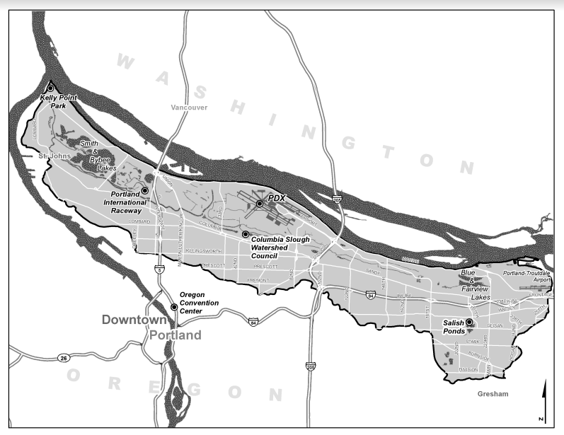
The Columbia Slough watershed drains 32,700 acres of land in Multnomah County and portions of the present-day municipalities of Fairview, Gresham, Maywood Park, and Wood Village.
There are over 60-miles of lakes, wetlands, and slow-moving channels that were formerly flooded each season by the Columbia River. Today, the Slough’s 19-mile main channel runs east-west, parallel to the Columbia River, and is intersected by more than 30 miles of secondary waterways that drain from the south.

Indigenous History
The area we know as the Columbia Slough watershed is the traditional homelands of the Upper Chinook peoples. The area rests on traditional village sites of the Multnomah, Clackamas, and Cascade bands of Chinook and the Tualatin band of Kalapuya. These Tribes and many others remain a vibrant part of the region and community today. The Neerchokikoo village rested near the site now known as Whitaker Ponds Nature Park.
At the crossroads of two significant rivers - the Columbia and the Willamette - the Tribes used the area to hunt, travel, and fish via the calmer waters of the Slough. Historically rich in plants, fish, and wildlife, the Slough and the surrounding area were home to salmon, sturgeon, camas, and wapato that were principal food sources for many Pacific Northwest Tribes.
During the early 19th century, non-native explorers including Lewis and Clark visited the area, leading the way for European settlers to forcibly remove Native people and build cities like Portland. Many Native people died due to smallpox and other European diseases during the “cold sick” epidemic of the early 1830’s.
Despite disease and violence, some Chinookan tribal members continued to live along the Slough, with the last documented original elder moving out in 1906.
Top Left Image Credit: Confluence Staff. “Upper Chinook: Multnomah, Clackamas and Wasco.” Confluence Project, 17 July 2019, www.confluenceproject.org/library-post/upper-chinook/. An illustration of drying beside the river. Engraving, J. M. Stanley. 1853. University of Washington Special Collections
Bottom Right Image Credit: Zenk, Henry, et al. “Chinookan Villages of the Lower Columbia.” Oregon Historical Quarterly, vol. 117, no. 1, 2016, p. 6., doi:10.5403/oregonhistq.117.1.0006. Courtesy of Tony A. Johnson, Chairman, Chinook Indian Nation
Beginning in 1918, levees were constructed to control seasonal flooding and make way for farms and slaughterhouses. The construction transformed the Columbia Slough into the channelized and highly managed system it is today.
In 1942, WWII brought new business to Portland in the form of shipbuilding by Kaiser Shipbuilding Company and the need to house ship workers. The city of Vanport was hastily built on reclaimed lowlands along the Columbia Slough and served as temporary housing for a diverse population of over 40,000 ship workers and their families.
When WWII ended, many Black residents and their families remained in Vanport because racist housing policies prohibited them from moving to Portland neighborhoods. After an unusually wet spring in 1948, the Columbia River experienced significantly high water levels, causing a railroad berm to give way and destroy the city of Vanport within hours. Residents were displaced and an unknown number of people lost their lives.
Due to discriminatory housing and lending policies, most Black residents had few choices of where to go and settled in the area that is today known as Albina.
150 years of industrial and residential development have left a damaged legacy of environmental problems across the Slough. The watershed continues to face challenges such as;
Deteriorating riparian habitat due to development
Excess aquatic vegetation from elevated stream temperatures due to loss of streamside shade and a warming climate
Contaminated sediments in bodies of water due to historic industrial and manufacturing activities
Polluted runoff from streets, parking lots, and developed land
Continued loss of natural areas and habitat due to urbanization and industrial development
Thanks to community action and enforced regulations, the Slough is cleaner today than in 100 years. Nevertheless, there is more work to be done. Check out our stewardship and volunteer page for more information on how to get involved.
Aquatic plants grow in the Columbia Slough’s shallow waters. Photo Credit: Zora Hess, 2020.
We just scratched the surface. Check out these resources to learn more about the past, present, and future of the Columbia Slough watershed:
City of Portland - Urban Watersheds 101
Multnomah County Drainage District - District History
Bureau of Environmental Services - Columbia Slough Watershed
Confluence Project - Upper Chinook
City of Portland Watershed Scorecard
Want to stay up to date on what’s happening in the watershed today?